The previous GeoCurrents post harshly criticized several climate maps for extending the subtropical zones too far toward the poles. But after doing a little casual research, I was chagrined to discover that these maps largely fit the formal, or “geographical,” definition of the term. The Wikipedia article on the subtropics states that “they cover the middle latitudes from 23°26′09.3 to approximately 35° to 40° north and south.” Both ChatGPT and Grok give the same figures. But in the United States, the subtropics are seldom if ever imagined in such terms. The idea that Chattanooga, Tennessee (35°N) is subtropical, let alone Columbus, Ohio (40°N), would strike most Americans as absurd. It is also noteworthy that very few maps that purport to depict the subtropics follow this latitudinal definition – and for good reason.

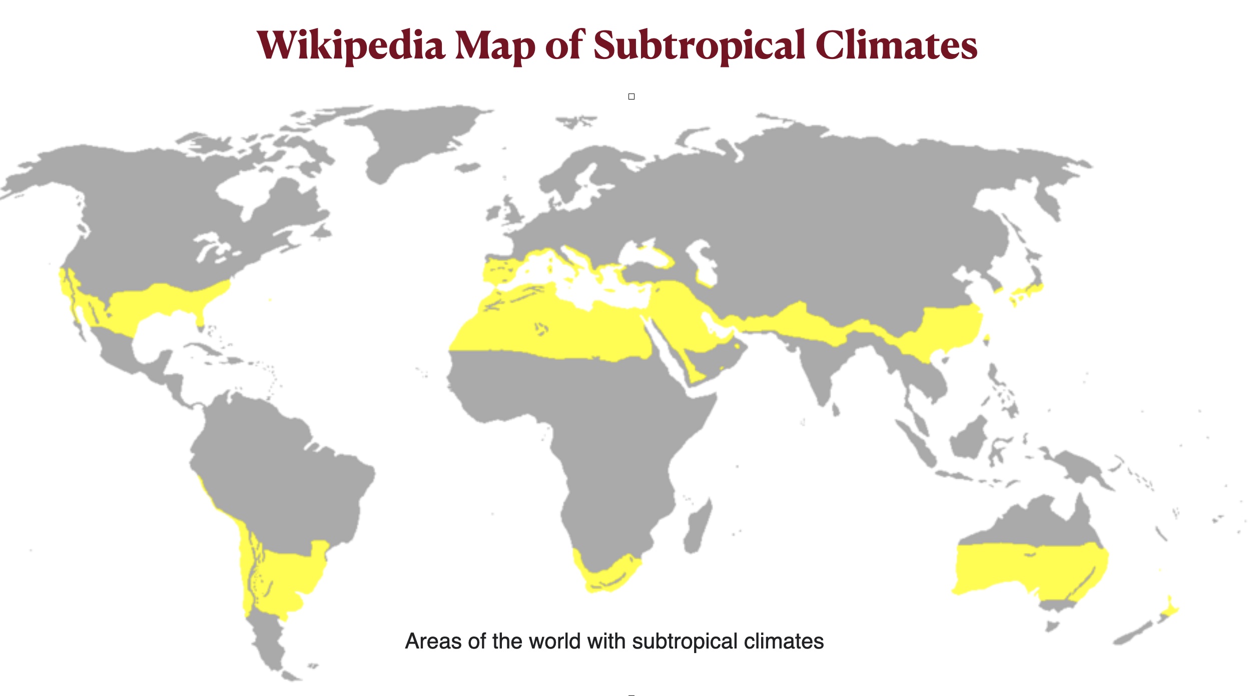
The main reason why the common conception of the subtropics does not match the formal definition is because the former is based on climate and climatic zones do not rigidly follow latitudinal belts. As can be seen below, the Wikipedia map of subtropical climates strays far from the lines of latitude that supposedly bound them. Although the Wikipedia article on the subtropics does not specify that the latitude-based definition of the term is quite different from the climatological definition, both ChatGPT and Grok do so. As a result, they give a better sense of what the term actually means.
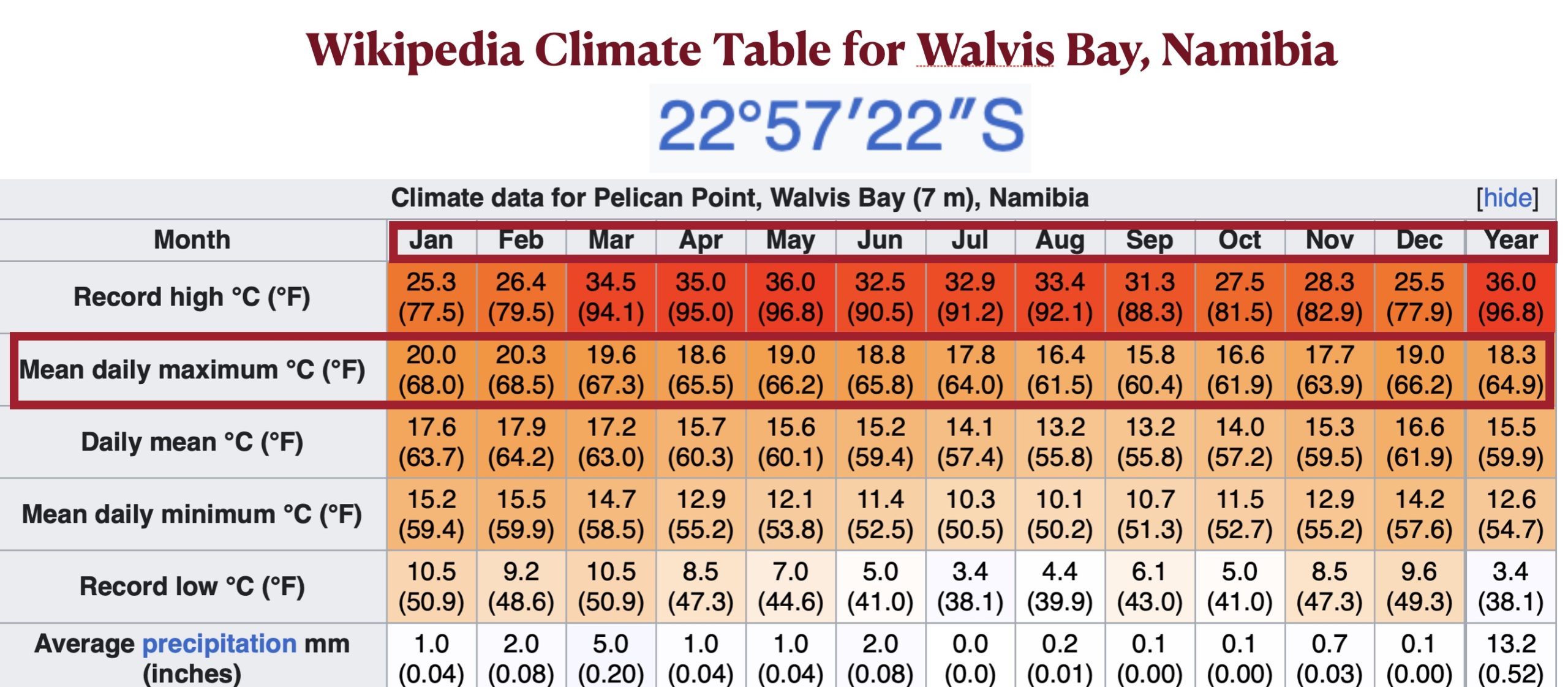
But even if we limit ourselves to the climatological subtropics, conceptual problems remain. To begin with, the definition of the term varies significantly from source to source. Such definitions, moreover, are often too vague to be useful. ChatGPT, for example, tells me that “Some meteorological sources define the subtropics as the region where [the] mean annual temperature is above 18°C (64°F) [and] winters are not cold enough for snow to be reliable,” but as this definition also includes the tropics. ChatGPT further claims that subtropical summers are hot, but that is not the case in many west-coast locations. In Walvis Bay, Namibia, which at 22°57’ is just north of the Tropic of Capricorn, not a single month has a mean daily maximum temperature above 68.5° F (20.3° C). Grok’s climatological definition of the subtropics, in contrast, is precise and seemingly scientific: “Regions where the average temperature of the coldest month is between 0–18 °C (32–64 °F) and the average temperature of the warmest month is above 22 °C (72 °F), following modified Köppen climate classification criteria.” But the “0–18 °C (32–64 °F)” coldest-month range is how the Köppen system defines temperate climates, not subtropical ones.
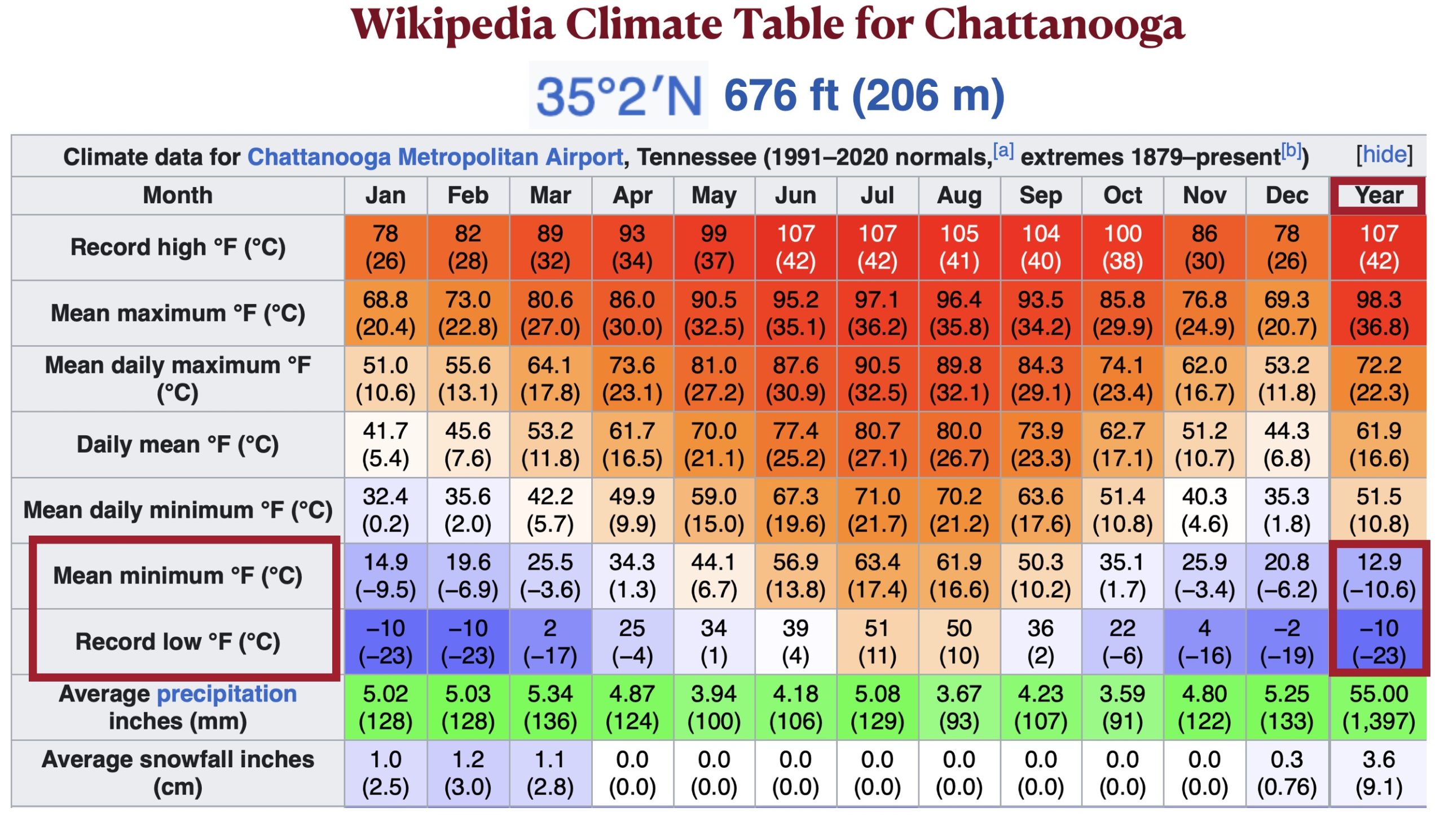
The Wikipedia article on the subtropics rests on more solid climatological grounds. It follows the Trewartha climate classification system in defining a subtropical climate as one “that has at least eight months with a mean temperature greater than 10 °C (50.0 °F) and at least one month with a mean temperature under 18 °C (64.4 °F).” The main problem with this definition is that it fails to exclude areas with short but chilly winters that have regular bouts of extreme cold – conditions that few people would regard as “subtropical.” Chattanooga, Tennessee, for example, easily slots into Trewartha’s humid subtropical zone, but its mean monthly minimum temperature in January is a frosty 15.9° F (-9.5° C) and its record low is a frigid -10° F (-23° C).
Another way to define the subtropics is by the geographical ranges of certain perennial plants, generally those that require a long period of relatively warm weather but can tolerate cool winters with occasional light frost. The Wikipedia article, for example, tells us that “These [subtropical] climates do not routinely see hard freezes or snow due to winter on average being above freezing, which allows plants such as palms and citrus to flourish.” By this criterion, my own home on the Stanford campus near Palo Alto, California (37° N), is definitely subtropical. But I doubt that anyone who grew up in the area would regard it as such. Most local people whom I queried seemed puzzled that I would even ask such a silly question. Several of them replied that Hawaii is the quintessential subtropical location. Actually, Hawaii is fully tropical (the northernmost point on Kauai is at 22°13′ N latitude).
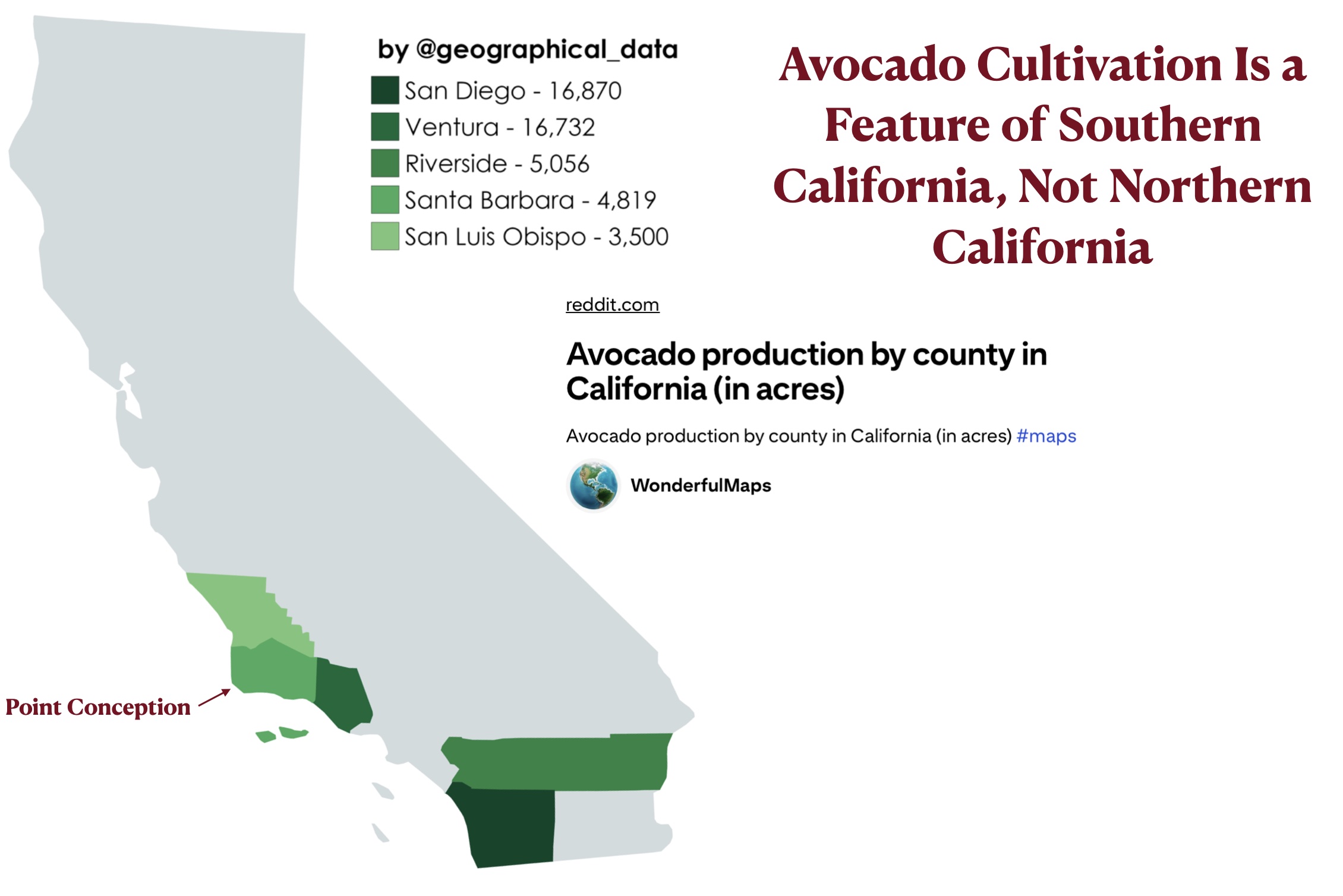
My own personal definition of the subtropics is keyed to a more comprehensive botanical list found in the same Wikipedia article: “plants such as palms, citrus, mango, pistachio, leechee, and avocado are grown in the subtropics.” Avocado trees cannot be successfully cultivated in Palo Alto, as they succumb to periodic frosts (Palo Alto’s mean annual minimum temperature is 28.1° F [-2.2° C]). When driving south, I can only start to imagine that I have entered the subtropics when I have rounded Point Conception and see the avocado orchards of southern California. Santa Barbara’s mean annual minimum temperature is 36.6° F (2.3° C) and frost-sensitive plants abound. But good luck with mangos and leechees.*
I do think that the “subtropics” is an indispensable geographical category. But it is necessary to clearly distinguish the “latitudinal subtropics” from the “climatological subtropics.” I also think that it is essential to consider regularly occurring extremely low temperatures when defining the subtropics on climatic grounds. These topics will be considered in greater length in coming GeoCurrents posts.
* As the map posted below shows, avocado orchards are found north of Point Conception in San Luis Obispo County, but I have never seen them.
**ChatGPT tells me that “You can grow mango trees in Santa Barbara if you have a warm microclimate and are willing to protect the tree during cold spells. They are not guaranteed producers…” It essentially gives the same answer for leechees.